

Our Mental Map Isn’t Accurate
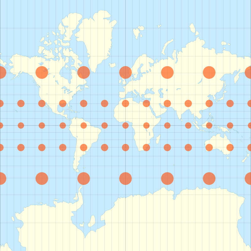
Distortion of the Mercator map projection can be seen through comparing the red dots. Though different sizes, each dot represents about a 621-mile diameter.
March 1, 2021
Think about that giant world map we’ve seen in at least one classroom. You know, the one that helped teach us geography. That square version of the world map, called the Mercator map projection, was initially used for navigation because of its accuracy in portraying directions and shapes. However, it is not completely accurate; in fact, it’s not even close.
Some continents seem to be totally misplaced. On most maps, Africa’s majority appears in the southern hemisphere, but in reality, it’s quite the opposite. According to National Geographic, around two-thirds of Africa is north of the equator. Africa isn’t the only continent placed much farther south than it actually is; Europe is too. Europe looks to be directly across from the US, but it is more accurate when lined up farther north, with Canada. Also, South America isn’t exactly south of North America. In truth, it’s more southeast.
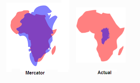
Furthermore, sizing on maps can be misleading as well. This reason is because when we use maps, we have just put our 3D world onto a flat 2D piece of paper. Flattening our world can’t be entirely without adjustment. For example, Greenland and South America appear to be about the same size on Mercator maps, but in reality, South America is eight times larger. Africa and Greenland also look the same size, but according to Business Insider, Africa is 14 times larger.
Distortions are not limited to paper maps, though. Even virtual maps created with satellites have their own distortions based on projections. According to GIS Lounge, currently, the US uses more that 18 different types of map projections. There is the Gnomonic projection, Stereographic projection, and many more.
Next time you look at a map, take time to consider what part of it is real and what part is distorted. Remember, understanding map projections is critical to ensuring accurate and precise mapping, but it also depends on what you are trying to use it for… finding Grandma’s house or finding the position of satellite may require the use of different maps.


